The cryosphere in the HKH region is an important research area since it is a major source of water resources and a potential source of hazards such as avalanches and flash floods. Our understanding of the cryosphere in the HKH is limited. It is partly due to the complexity of the topography, as well as the lack of subject experts.
More cryosphere researchers are needed to manage the cryosphere resources in the region. My goal is to help young researchers in the region develop their research skills. As someone who has taken more than 20 technical courses related to cryospheres and organized cryosphere training for ICIMOD, I am motivated to share my knowledge and experience with others through training workshops.
Training conducted as a resource person
1.Seven days Crash Course in R 2018 [ PDF ]
2.Glacio-hydrological analysis using R 2019
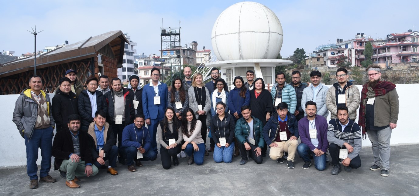
This was a four day physical training from 17th to 20th of December 2019. The training was intended to build the capacity of regional partners in using the R programming language for glacio-hydrological analysis which includes hydrological and meteorological time series data analysis, spatio-temporal analysis of includes APHRODITE precipitation, calculation of glacier wide mass balance from point mass balance, analysis of Ground Surface Temperature for permafrost studies and MODIS data for snow cover area calculation. A total of 20 researchers from three different countries attended the training-workshop, including 25% women.
3.Glacier mass balance modelling using R 2020
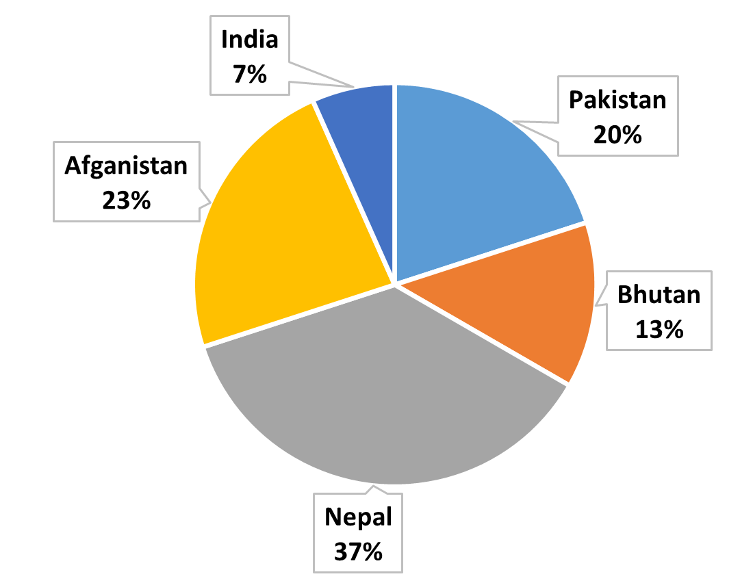
A seven-day virtual training program was conducted from December 14th to 22nd, 2020. The objective of the training was to build capacity of regional partners on using R programing language for spatial data analysis and glacier mass balance modelling. A total of 3O researchers from five different countries attended the training. Twenty participants were nominated by the key organization responsible for the cryosphere research in the HKH region, while 10 were selected through an open call. A total of 174 people applied for the 10 positions available. In conclusion, this clearly demonstrates the need for cryosphere-based training and the interest of people in it.


4.Snow data analysis in the Hindu Kush Himalaya region using R and Google Earth Engine 2021
From August 23–27, 2021, a regional virtual training on snow data analysis in the HKH region using R and GEE software was held. We had 31 participants in total, of whom 11 were nominated by our partner organizations from the HKH region and the remaining 20 were chosen from the applications submitted in response to the open call. We received 156 applications for the 20 open call jobs. The training addressed a variety of snow-related subjects, such as field-based snow data measurement, snow remote sensing, and the dominant snow process across the HKH region. The use and advantages of open-source software, particularly R and Google Earth Engine (GEE), for the analysis of snow data were explained, demonstrated to the students and participants. The participants received hands-on training every day to help them use R and GEE software to address their own problems.
5.Remote sensing and field-based glacier and snow monitoring in Pakistan 2021
Early-career researchers and students in Pakistan received training in remote sensing and field-based glacier and snow monitoring from March 14-March 17, 2022. During the training, students and professionals learnt how to conduct field-based glacier mass balance and remote sensing of snow and glaciers. The seminar was attended by a total of 36 people from 22 partner agencies. Participants from partners were nominated by their organization whereas 18 positions were filled through open call selection. More than 550 people expressed interest in taking part in the program, but owing to resource limitations, we could only accept 18 of them.
6.Analysing permafrost in the Hindu Kush Himalaya using open access tools 2022
A five-day in-person training was organized from 20th to 24th June 2022. There were a total of 29 participants, with 15 coming from key partners (hydromet agencies) and the remaining 14 from open calls. Overall, 301 people applied for 14 open positions, indicating a strong interest in permafrost. The training was a mixture of theoretical lectures, demos and hands-on exercise related to permafrost, permafrost hazards, spatial downscaling of temperature data, analysis of SRTM DEM and ground surface temperature and preparation of permafrost maps. Freely available softwares like R and Python were used in the training. All of the resources are prepared using Google Colab, which is available for free to anyone.
Training taken as a participant
21.HydroSAR data products and web application organized by ICIMOD and University of Alaska Fairbanks within the framework of the SERVIR-HKH initiative, 8 June, 21-23 June, 2021.
20.Modelling surface flow hazardconducted by Himalayan University Consortium, ICIMOD and University of BRISTOL, 8 June, 21-23 June, 2021 [ PDF ].
19.Monitoring Snow Water Equivalent (SWE) for estimating snow water volume in the HKH region conducted by SERVIR HKH, ICIMOD and Cold World Consulting (CWC) USA, 26 April - 05 May, 2021.
18.HydroSAR training: Extracting flood information from SAR organized by SERVIR HKH ICIMOD facilitated by the University of Alaska Fairbanks, 26– 29 January, 2021 [ PDF ]
17.Knowledge Management and Communication organized by Cryosphere Initiative, ICIMOD, 19 – 23 October, 2020 [ PDF ]
16.Participated in Machine Learning Training organized by SERVIR HKH, ICIMOD facilitated by NASA and Development Seed, 29 September – 14 October, 2020.
15.Hydrology and use of models and satellite images in water resources mapping organized by Norwegian Water Resources and Energy Directorate (NVE), Oslo, Norway at Oslo, 29 February – 7 Janaury, 2020.
14.HEC RAS Flood Modelling organized by ICIMOD, at ICIMOD, Kathmandu, Nepal with the support from the Government of Norway, 23 – 27 April, 2018.
13.Beginner training on Google Earth Engine organized by ICIMOD, at ICIMOD, Kathmandu, Nepal within the framework of SERVIR-HKH supported by USAID and NASA, 9 – 13 April, 2018.
12.Hydrological modelling in the Hindu Kush Himalaya using VIC model organized by ICIMOD, at ICIMOD, Kathmandu, Nepal, 21 – 23 May, 2017.
11.Hydrological Modelling in the Hindu Kush Himalaya using SPHY model organized by ICIMOD at ICIMOD, Kathmandu, Nepal, 16 – 19 May, 2017.
10.Digital soil mapping” organized by the International Maize and Wheat Improvement Center (CIMMYT) and ISRIC at Lalitpur, Nepal, 27 – 31 March, 2017.
9.Sentinel Satellites Data Analysis organized by the ICIMOD and EURAC RESEARCH Bozen/Bolzano, Italy at ICIMOD, Nepal, 30 Janaury – 3 February, 2017
8.Field techniques and data tools for monitoring high mountain environments: Applications in permafrost jointly organized by University of Zurich and the WSL Institute for Snow and Avalanche Research (SLF), Switzerland at Kathmandu Unuversity, Dhulikhel, Nepal, 23 – 24, October 2016 [ PDF ]
7.Data Analysis Using R organized by KU at KU, 22 – 24 June, 2016 [ PDF ]
6.Data Analysis with R organized by ICIMOD at ICIMOD, 12 – 15 January, 2016 [ PDF ]
5.Application of Remote Sensing and Geographic Information Systems for Mapping and Monitoring of Glaciers organized by ICIMOD at ICIMOD, 18 – 22 January, 2016 [ PDF ]
4.Snow modeling, model sensitivity and uncertainty analysis, snow measurement techniques, data-assimilation and operational flood forecasting, as well as practical lessons on programming in “R” statistical software and on river discharge measurements organized by Norwegian Water Resources and Energy Directorate (NVE), Oslo, Norway at Oslo, 31 August - 11 September, 2015 [ PDF ]
3.Glacio-Hydrological Training organized by Himalayan Cryosphere, Climate and Disaster Research Centre (HiCCDRC), Kathmandu University at Pokhara, Nepal, 13-16 December, 2014 [ PDF ]
2.Glacier Mass Balance Monitoring organized by ICIMOD at ICIMOD, 14 – 17 October, 2014 [ PDF ]
1.International Youth leadership Camp, 2010 organized by Youth Action Nepal and Leaders in Community (UK), 17 – 20 September, 2010 [ PDF ]
